5 Sebaldus Tour St. Georgen Round - The Dragon Slayer


- culturally interesting
- Flatly
Interactive elevation profile
Create PDF
Tour-Details
Paths covering:
A very beautiful day tour with a long and a short variant.
The tour on Outdooractive - registration on the platform required
The tour on Komoot - registration on the platform required
The tour on Bergfex - registration on the platform not required
The tour on sebaldustour.at - no registration on the platform required
Technique: ***
Quality of experience: ***
Recommended season:
- April
- May
- June
- July
- August
- September
- October
Properties:
- Round trip
- Loop
- Refreshment stops available
- Cultural/historical value
Eine sehr schöne Tagestour mit einer langen und einer kurzen Variante
Die Tour auf Outdooractive - Registrierung auf der Plattform erforderlich
Die Tour auf Komoot - Registrierung auf der Plattform erforderlich
Die Tour auf Bergfex - Anmeldung auf der Plattform nicht erforderlich
Die Tour auf sebaldustour.at - Anmeldung auf der Plattform nicht erforderlich
Directions:
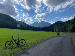
From Gaflenz/Weyer, the route climbs slightly to Pichlhöh-Saurüssel, followed by a brisk descent to Kleinhollenstein, then left for a few hundred metres until it joins the Ybbstal cycle path, which is marked with large arrows.
After 3 km you reach the former Großhollenstein railway station. This is the start of the short stage. The route continues past the Schafkäsexpress to the village square - on towards Dornleiten, past the marvellous Hammerherren houses, steadily uphill to the highest point of the stage: the Promau, with views of the Voralpe and the Stumpfmauer, the highest elevation in the municipality of Weyer. This is followed by the descent to the Mendlingtal manor house, where you can stop for a drink before the next 2 km climb (somewhat steeper). The route then descends to Lassing, continuing downhill on the road to Göstling, where you can stop for refreshments in the late Baroque parish church.
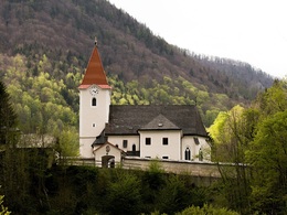
From here, you turn back onto the Ybstal cycle path, past the brine baths, and cycle along it downstream to our destination church of St. Georgen am Reith.
On the short, steep ascent there, you pass the "Gulaschwirtin" inn, which won the Lower Austrian goulash competition in 2002.
The route continues towards Hollenstein, where the popular lido invites you to refresh yourself.
Those who have chosen the short stage return to Weyer or Gaflenz by car.
FFor the others, the trail first leads further downstream to Kleinhollenstein and from there uphill to the Saurüssel and from there downhill back to the starting points
Safety guidelines:
Please note: For environmental reasons, extensive signposting has been largely dispensed with along the route. A map and GPX data provide the necessary safety.
Equipment:
Cycling helmet, first aid pack for rider and bike
further information:
- Flatly
- Board possible


- Spring
- Summer
- Autumn
Please get in touch for more information.
Stadtplatz 27
4400 Steyr
Phone +43 7252 53229 - 0
E-Mail info@steyr-nationalpark.at
Web www.steyr-nationalpark.at/
Interactive elevation profile
Create PDF
Tour-Details
Paths covering:
