6 Sebaldustour Brunnbachrunde - The national park pearl


- culturally interesting
- Multi-day tour
- Flatly
Interactive elevation profile
Create PDF
Tour-Details
Paths covering:
The Brunnbach loop leads along the Enns cycle path to Reichraming, through Anzenbach and the Reichraminger Gebirge mountains to Brunnbach and the Brunnbach church. The route continues via the Lumplgraben to Großraming, where you cycle back to the starting point on the Enns Cycle Path.
The tour on Outdooractive - registration on the platform required
The tour on Komoot - registration on the platform requiredThe tour on Bergfex - registration on the platform not requiredThe tour on sebaldustour.at - registration on the platform not required
Technique: ***
Quality of experience: ****
Recommended season:
- April
- May
- June
- July
- August
- September
- October
Properties:
- Round trip
- Loop
- Multi-stage route
- Scenic
- Refreshment stops available
- Cultural/historical value
Die Tour auf Outdooractive - Registrierung auf der Plattform erforderlich
Die Tour auf Komoot - Registrierung auf der Plattform erforderlich
Die Tour auf Bergfex - Anmeldung auf der Plattform nicht erforderlich
Die Tour auf sebaldustour.at - Anmeldung auf der Plattform nicht erforderlich
Directions:
The Brunnbach circuit leads along the very popular Enns cycle path R7, initially rather flat downstream to Großraming.
If you choose the short stage, you can start at Großraming railway station.
Shortly before the rafting village, a turn-off leads to the impressive suspension rope bridge (5 min. on foot). The route then continues past the carriage museum and the nativity scene exhibition to Reichraming. From the town centre, take the asphalt road past the Schallau arena for approx. 6 km to the Anzenbach car park. This is where the Hintergebirgsradweg cycle path in the Kalkalpen National Park begins, offering beautiful views of the many enchanting bathing spots along the Reichramingbach stream. It is not tarmac, but is very easy to cycle on. After 2 km, turn right to the Große Klause, once the central timber drift in the Hintergebirge.
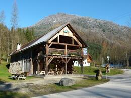
The Klaushütte, which served as accommodation for the lumberjacks, invites you to stop for a bite to eat. Open in fine weather from Wednesday to Sunday.
After the rest stop, return along the same route for approx. 6 km, then turn right towards Brunnbach with the Brunnbachstadel, which is usually only open at weekends. From there, the route climbs steeply for approx. 1 km to the Brunnbach church and continues briskly downhill over the Gschwendthöhe with its beautiful chapel via the Lumplgraben back to Großraming. The route leads back to Weyer and Gaflenz on the Enns cycle path R7.
If you are already tired, take the train back.
Safety guidelines:
Please note: For environmental reasons, extensive signposting has been largely dispensed with along the route. A map and GPX data provide the necessary safety.
Equipment:
Bicycle helmet, first aid pack for rider and bicycle
further information:
- Multi-day tour
- Flatly
- Board possible


- Spring
- Summer
- Autumn
Please get in touch for more information.
Stadtplatz 27
4400 Steyr
Phone +43 7252 53229 - 0
E-Mail info@steyr-nationalpark.at
Web www.steyr-nationalpark.at/
Interactive elevation profile
Create PDF
Tour-Details
Paths covering:
